5-6 November 2005 Coronet Peak and Cotter Rocks Photos
Maps: Rendezvous Creek 8626-1S Second Edition 1:25000; Corin Dam 8626-1N Second Edition 1:25000
Getting There

Having spent a year as a member of the Canberra Bushwalking Club and having several experienced members share their bushcraft with me, time came for me to put a little back in.  So I offered to lead a walk.  I've been to Split Rock before and planned to take an experienced club walker with me, so we'd know exactly where we're lost!  We gathered from the north side at my home, then various cars picked up various south side participants.  We all rendezvoused at Tharwa, happening on an RV of the club's Cotter Hut broom clearers.  It was great to briefly catch up with old friends.  We then drove on and parked at the Orroral Tracking Station car park.  There must have been 20 rural fire service vehicles parked at Namadgi Visitors Centre.

The main feature of Cotter Rocks is identified as Split Rock Pinnacle in ACT Granite, p 193.

Walk

An excellent introduction to the granite tors of the Bimberi Wilderness in Namadgi National Park.  We’ll walk a variety of locations including Orroral Valley grasslands, fire trail, the Australian Alpine Walking Track and some off-track bush.  An (optional) side trip to the unique Split Rock, then camp at Pond Creek Flats.  On Sunday, we’ll climb Coronet Peak (1494m), then return to our camp site to pick up packs and walk out.  This will be a great trip for new (and old) club members.  If you haven’t got all the gear, hire from the club.  Maps: Corin Dam 1:25000, Rendezvous Creek 1:25000.  Leader: John Evans (h) 6288 7235 (e) jevans@pcug.org.au  Transport: $8.50.  Limit 8, so book early.  More information at www.pcug.org.au/‾jevans .

I've done a recce past Split Rock and Coronet Peak.

Saturday

11 of us kitted up, 8 happy campers and 3 day trippers, yeah.  We were walking by 9.05am, heading through the kangaroos as we walked up the Orroral Valley grasslands to keep off the hard surfaced Cotter Hut Road.  But we had to join it and were passed by 2 fire service vehicles, no doubt on a pre-season exercise.  It was pleasant walking on a mild, sunny morning and we had our first stop for 5 minutes after 1 hour and 3.6km.  Great views, as usual, up to Orroral Ridge (the Ridge of Stone) - the Belfry, the Cloisters, Tower Rocks and Legoland I recognise.  I was interested in timings, having day walked this area at a reasonable pace, but had little idea of a larger group with overnight packs.

We reached the point where the AAWT turns off Cotter Hut Road at 10.35am.  5.6km in 1.5hrs.  We took another short break.  This next leg across to Sawpit Creek is quite pleasant.  The bush is regenerating nicely and at this time of the year some nice wild flowers.  Sawpit Creek was reached at 11.05am, the appointed hour for a 15 minute morning tea.  2 hours and 7.6km from the cars.

Next came the steady pull up to Cotter Gap which we reached at 12.05pm.  So 3 hours to here, around about a 50% premium on a reasonable pace with day packs.  We took a 10 minute break and, after transferring lunch and water into day packs, 10 of us headed up to Split Rock.

It took an hour to get there, still an incredible feature for first time visitors and those returning.  That terrible graffiti plaque is still there!  We climbed the luncheon rock next to the split and spent a 30 minute lunch enjoying the sights.

Back down by 2.15pm, we said good-bye to our day walking companions.  They had an 11km return trip, the remainder of us a mere 3km down to Pond Creek Flats.

We reached our camp site at 3.30pm.  I was grateful for a hint from John K as to where to camp.  I had planned to go about 500m in off the AAWT to near Pond Creek - the recognised camp spot is, in fact, just a couple of tens of metres in to the right immediately after crossing the tributary creek to Pond Creek.  A very pleasant elongated area with plenty of room for 8 tents.  GR6795855151 (MGA 94).  An obvious fire place marked the 'kitchen area' (although we didn't flout the rules by lighting a fire) and we had plenty of time to set up house, make a cuppa and relax.  No-one (including myself) was anxious to make the 6km round trip down to Cotter Hut to see how the broom clearers went.  We had tea around 6pm, then an evening storm rolled around to the south, with its edge bringing light rain for a few hours.  That, unfortunately, dampened prolonged communal activity.
1 Inside Split Rock
2 Split Rock from Cotter Gap
3 Storm clouds over Coronet Peak from Pond Creek Flats camp site
 

Sunday

I woke at 5.45am to the snores of an (unnamed) camper in a nearby tent!  No worries, though, as I've picked up the decadent habit from an (unnamed) ex-Tasmanian mentor of breakfasting in bed.  The MSR pocket rocket gas stove I've settled on for weekend trips is perfect for firing up in the tent vestibule.  I watched the cloud base lower down to hide Cotter Rocks and Coronet Peak, hoping that it would lift.

An 8am start had been advertised and 6 of us shouldered day packs at 8.06am (grrr - 6 minutes late!).  We stepped back to the AAWT, skirted the big 'pond' and headed 350m along the track to where I'd set a GPS waypoint from the first edition Rendezvous Creek 1:25000 map which shows a track heading SSE to Little Creamy Flats (this track is not on the 2nd edition map).  I hadn't been able to recognise it on my recce trip, but there it obviously was, clearly marked by an ant hill on the right.

This was now new territory for me and the responsibility to get us to the top of Coronet Peak started to weigh a little heavy.  I'd asked a few experienced hands for hints, but all I'd gleaned was "it's fairly open scrub with a good granite cap at the top".  All a map recce suggested was head up the spur just east of north after leaving the old track.

We followed the track for around 350m until it started to turn away from Coronet Peak, then headed bush.  It was reasonably open bush and reasonably up.  We reached the granite cap at a point just N of W and followed a wide ledge to the south.  No luck there.  So we turned and headed clockwise round the N side of the cap.  Around nearly to the E, John O found a slot which took us via an easy scramble to the top, reaching it at 9.15am.

Magnificent.  Even with the cloud base down!  Uninterrupted, sweeping 360deg views!  Starting from the west, we could see Cotter Hut and the Cotter Flats.  The top of Bimberi Peak was in the clouds.  Then around to the Cotter River Valley with the Brindabellas above it, the western end of de Salis Knobs with our camp site below, Pond Creek cut heading up to Cotter Gap, the western flank of Cotter Rocks and Creamy Flats Creek up to Little Creamy Flats.  Sadly, the top of Mt Namadgi was in the clouds and Mt Burbidge could not be seen - this was the particular view I'd come to see.  Then round to Licking Hole Creek valley, Mt Kelly spur, the Cotter River Valley with Upper Cotter Flats and so back to the roof of Cotter Hut.  Truly wonderful.  We spent 30 minutes taking in the view.  Our companions below said they could see us from the camp site, albeit as moving trees.

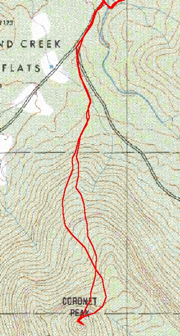
A closeup of our route is below.  The upward leg is first the more easterly, then crossing to the west.  The downward leg started to the NE, then swinging back and crossing the upward leg to be the more westerly route.  No reason but that we were using visual navigation and different people were making the path at different times.  And with the bush wet from the overnight rain, I was quite happy to let someone else go first to knock the water off the bushes!  As it turned out, the beginning half of the upward leg was best and the beginning half of the downward leg was best.  I was leading on the last of the downward leg and we came in on the old Little Creamy Flats track exactly were we left it.  At the time, I claimed superb navigation skills, but now admit to my companions and the world that it was pure luck!

We were back at the camp site by 10.45am, all the pressure off me now.  Just walk out.  We purposefully split the party to allow people to walk at their own pace back up to Cotter Gap.  I was interested in doing some more timing, so I walked alone at my own pace the 3km and 230m up, doing it in 45 minutes.  Others took  1 hour and 5 minutes.  More lessons for moving a group.

We lunched at Cotter Gap and enjoyed the company of a guy who was walking alone back from Murrays Gap (he was training to go to Nepal!).

Again at our various sub group paces, we walked back to our starting point, the tail reaching the cars at 3.00pm.

I really enjoyed the weekend, both the company of my fellow walkers and the huge scenery.  I'd encouraged all to bring something to share and it was great to see people sharing scroggin, carbohydrate (with the walker who'd packed in a rush!), carrying someone else's lunch in a day pack, walking poles for the slightly lame, making a cuppa for a mate, the latest information on walks and gear, good red wine (yum!), bikkies and cheese and port - as well as, of course, conversation.  Awards were handed out at the end.

Thanks all - Lauraine R, Ralph Y, John O'H, Mark B, Anthony T, Tom G, Jenny W, John K, Kim H and Quentin M.  I had a ball.

4 Donkey orchid
5 Slot up to the top of Coronet Peak from the east side
6 Panorama view from Coronet Peak

Home